If you are heading clockwise around the South West Coastal Path then after the heights of High Cliff this part will be a doddle. A lovely flatish section of coastal path, without the climbs and drops of the previous parts. A chance to walk along a beach as well, without worrying about the high cliff ahead. The walk itself has some lovely views, especially from the cliffs around Bude, and the walk back is very good, crossing a golf course and walking along a canal. Now canals in Devon and Cornwall are found as often as rocking horse poop, but Bude has one, and its a joy to walk it. The canal leaves the houses and harbour area quickly before finding itself out in fields on a meander through the countryside. After that I picked up a path which linked me back to Widemouth Bay and those glorious seaside views again. An absolute cracker of a walk some stunning views, with so much going for it and a want to carry on along this section, can’t wait to be back here.
Start – Wanson
Route –South West Coastal Path – Widemouth Bay – Salthouse – Efford Beacon – Compass Point – Bude Beach – Crooklets Beach – Northcott Mouth – Maer – Bude Golf Course – Bude Canal – Helebridge – Salthouse – Widemouth Bay – Wanson
Distance – 12.5 miles Start time – 9.30am Time taken – 5hrs 30mins Highest Point – Nothing over 60 metres
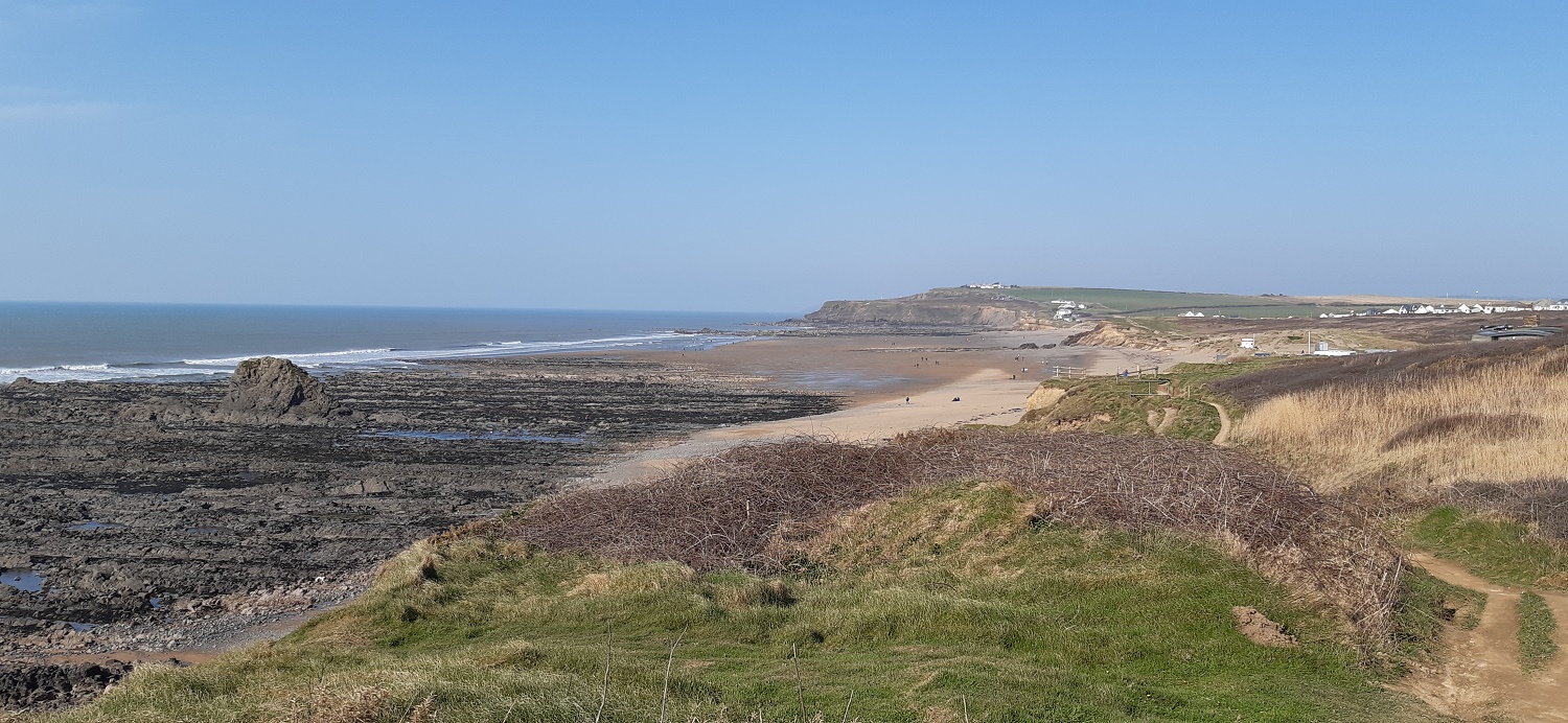
A scruffy start to a lovely walk. This is Wanson and where I ended my last coastal walk in this part (here). I’d noticed these laybys which made for a good place to start this walk.Wanson Beach and some lovely sunshine, blue is the colour of the dayOh wow, Widemouth Bay and a killer viewLooking back west to the Penhalt Cliffs and High Cliff areaOn Widemouth Beach now, its always best to walk along the sand if you canGlorious walking across here, I’m heading for the white buildings low down by the beach in the distanceAt the top I put that it was very windy today, here it shows some of that. The top of the waves were being taken back out to sea, whipped away by the strong windWidemouth Bay and beachHeading up to Lower Longbeak and the views are along the beach. Away on the right the furthest point sticking out is Cambeak which is near Crackington HavenThe large satellite dishes of GCHQ Morwenstow are in the distance looking northA bit higher up, you can see clearly along this section the erosion taking place, the jagged edges of the cliffs giving it all awaySome stunning rocky scenery along hereGCHQ MorwenstowThe outskirts of Bude come into view nowOpen grassy paths lead down to Bude and its harbourA look back along the part already walked and again that rocky shorelineNearly at Bude now, I’ll head to the trig point over there first and then the ground starts to fall towards BudeThe trig point at Efford BeaconBude beach, or Bude Haven as it is marked on the mapsThe tower at Compass Point, which naturally has the compass directions written across the topThe outdoor lido at Bude, quite a few either in it or warming up having been in it.I’d stopped for a coffee and cake in a café at Crooklets Beach, before a short climb up to Maer Cliff. The distance views today weren’t great but still I’m not complaining with the sun out and it was reasonably warm, you can just make out Trevose Head in the distance nowNorthcott Mouth with the path rising up to Menachurch Point beyond. This is as far as I went today, another 5 1/2 miles of the coastal path ticked off, now to turn inland and make my way back towards BudeMental note made for the future that this is a National Trust car park here, so free parking for me on the next leg along this part of the coastThink that’s Poughill over there as I follow some lanes wriggling back towards BudeBude golf course, which is pretty much in the middle of the townThe River Neet running through the centre of Bude, I’m about to cross it on a bridge behind me before picking up the canal path out of BudeBude Canal, it was opened in the 1820s to take minerals and sand from the beach to the agricultural farms inland. It ran for 35 miles up to an altitude of 132metres from Bude to Druxton Wharf near to LauncestonCommon Moorhen on the canalSmall tortoiseshell, in March!! Good job the celandine flowers are out already hereNearing Helebridge now and I look back along the couple of miles of canal walking done Some locks. Part of the raising of the canal up that 132metresAt Helebridge I turned right at a fishing lake to cross the farmland towards Salthouse. A glorious view to Widemouth Bay opens up as I reach the high point and start to drop downBack on Widemouth Beach now, I stayed on the left hand edge this time, picking up the coastal path through the car parksAt the far end of Widemouth Beach now, looking backHazy views of Penhalt CliffsOne last look at Widemouth Bay at the end of a superb walk in lovely weather. A perfect day out.
Stayed for a few days at Penhalt Farm campsite a few years back but didn’t walk the coast or the canal as we were playing in the waves at Widemouth. Great stretch of easy walking
We camped in Dorset many years ago and visited Durdle Door, Lulworth Cove etc. Before my blogging days. And we’ve stayed in Cornwall nearish Bude but inland in a quirky Showman’s Wagon at Vintage Breaks in Rezare.


Years since I’ve done, but a lovely bit of wilder coast.
LikeLiked by 1 person
I can imagine it was brutal with those recent storms coming in from the west straight on to that coastline
LikeLike
I certainly seen some rough weather on that coast, As used by Daniel Coppinger the notorious wrecker.
LikeLiked by 1 person
As used by Daniel Coppinger he notorious wrecker.
LikeLike
Stayed for a few days at Penhalt Farm campsite a few years back but didn’t walk the coast or the canal as we were playing in the waves at Widemouth. Great stretch of easy walking
LikeLiked by 1 person
Widemouth is probably my favourite of the larger beaches that I’ve done so far. Plenty surfing in the sea when I was there as well
LikeLiked by 1 person
I have actually been to Bude! Somewhere I have been in your walks for a change.
Good to see the first butterflys. I have also seen Small Tortoishell.
LikeLiked by 1 person
I’ll be in the Lakes in a couple of weeks so a chance for some more familiar views!! Is there anywhere else in the south west you have also been to?
LikeLike
We camped in Dorset many years ago and visited Durdle Door, Lulworth Cove etc. Before my blogging days. And we’ve stayed in Cornwall nearish Bude but inland in a quirky Showman’s Wagon at Vintage Breaks in Rezare.
LikeLiked by 1 person
Wonderful photos beautiful place thanks for taking there.😊👍
LikeLiked by 1 person
Beautiful. These open views on the cliffs and fields are great. I like the lido I am not sure I will be brave enough to swim in it though 🥶.
LikeLiked by 1 person
Have to be honest, those coming out looked pretty cold and hadn’t been in for long!!
LikeLiked by 1 person