Having summited the highest Wainwright and mountain in England two days earlier, we figured that we would also summit the second highest. This was a walk made to shorten the number of walks I have left, by one at least, and as a result I conjured up the longest walk I’ve done on any of my Wainwright walks. 14 miles setting out from an absolute peach of a valley and from a car park that would rarely ever fill up. As it was we arrived just before 10am and only one other car was parked up and they were still putting their boots on. We started out through the forest, climbing on a mix of forest tracks and paths between the trees, before long we popped out on to Irton Fell to see cloudy views and clouds swirling around Whin Rigg and the Wasdale fells. The forecast was for the cloud to clear and blue skies to come out during the afternoon, the MWIS forecast was spot on and as we climbed so did the cloud. This walk would include lots of places and views that I’ve always wanted to see. Like looking down the Wasdale Screes and across Wastwater to Yewbarrow, Burnmoor Tarn and the views into Eskdale from Scafell and Slight Side. So much to see but many miles to get there, and with hardly anyone else around, a complete contrast to our walk up The Pike, this was to be a special outing. We really enjoyed walking across the top of Whin Rigg and Illgill Head, and even had a first lunch at the tarns between the two. However on descending to the Maiden Castle cairn we noticed it was 2.30pm already and we were about to start a 660metre climb to Scafell, we quickly got to Hard Rigg following what seemed to be a good path, it turned towards Green How and became a little feint but still good to follow, then we hit boggy, mossy ground, which when heading uphill and in a warm sun is sapping on the energy. In the end we reached the path which comes up over Green How from Wasdale Head, and with it, firmer ground.
We finally hit the summit of Scafell at 4.50pm and with it views for miles, we sat for a while eating lunch number two and soaked up the sunshine and the staggering scenery. Eventually we dragged ourselves away and headed down to Slight Side, the sun had started to hit a slight golden stage and the light looking down into Eskdale was stunning, by this point it was 6.15pm and we still had just over 5 miles to walk back! We decided we would head over to cross the two gills as high up them as possible. We had seen on our ascent of Scafell that were was a lot of water in Hardrigg Gill and also Broad Tongue seemed to have a lot of standing water and looked boggy. We made the right call and easily hopped the gills before dropping to Burnmoor Tarn, it was a bit squidgy around the tarn but we made swift progress around to Burnmoor Lodge. Then we heard a roar in the Wasdale valley, I shouted “planes”, and as I grabbed my camera we saw two banking Eurofighter Typhoon turning hard at the end of Illgill Head before screaming over the tarn and us and heading down the Western Lakes coast. We were still giddy as we dropped into Miterdale to see two stunning waterfalls falling into the valley. It was 7.45pm at this point and we still had 3 miles to walk to the car, Miterdale is a long way, thankfully the light is good until 9pm in the middle of May and we made quick progress alongside the river. That is apart from me slipping twice on greasy ground. It didn’t spoil what was a truly stunning day and one of my best days walking anywhere. I’m just grateful to have shared it with Linda and we got to see clear summit views from the top of Scafell which is a memory that will live long. The crowning part was that Scafell was number 200 of my Wainwrights, a perfect way to hit that milestone. Apologies for the number of photos, but there is just so much to see.
Start – Miterdale parking
Route – Miterdale Forest – Irton Fell – Whin Rigg – Illgill Head – Hard Rigg – Green How – Scafell – Slight Side – Hardrigg Gill – Burnmoor Tarn and Lodge – Miterdale
Distance – 14 miles Start time – 10am Time taken – 10hrs 30mins Highest Point – Scafell 964 metres
Weather – Cloud to start but lifting to blue skies, sun and glorious conditions
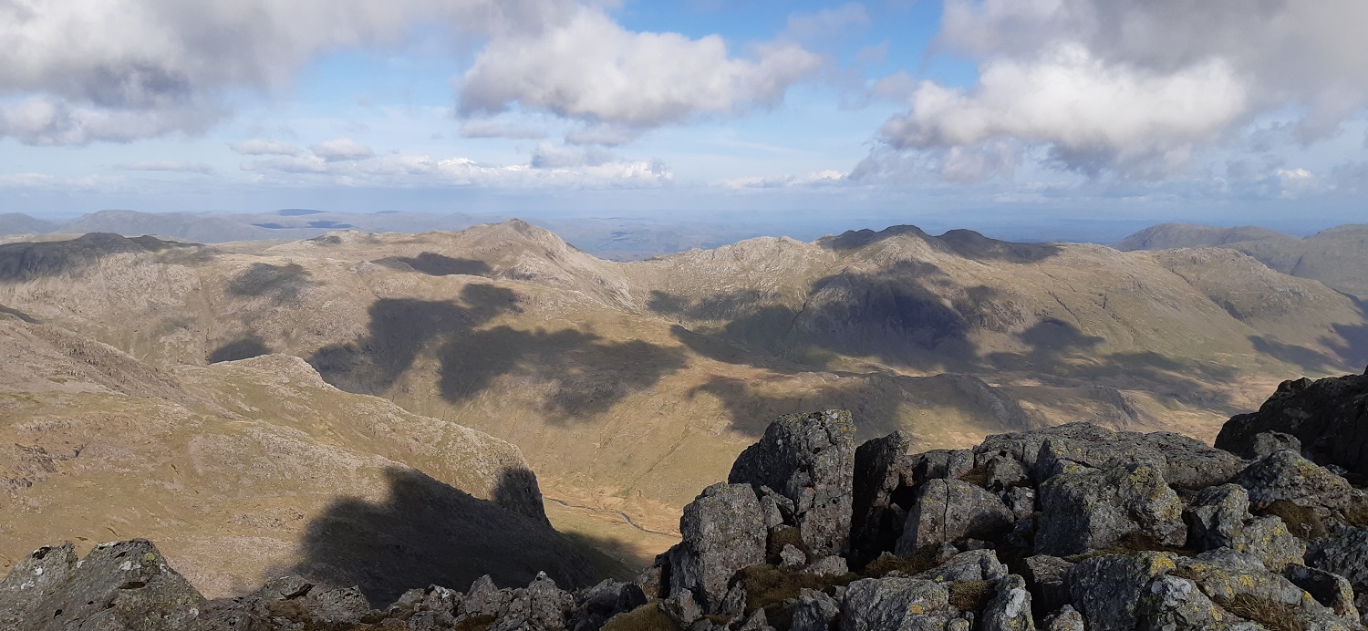
The parking spot at Miterdale is a grassy pull off area by a forest track and this bridge. Miterdale is in the direction of the photo, we are heading up to the left hereGreat Bank dominates this end of MiterdaleAs we popped out of the forest and through the wall we see views back towards the coast and Irton PikeWhin Rigg was in and out of the clouds as was Wasdale and the fells to the leftGreathall Gill is an ascent to Whin Rigg if you are coming up from Wasdale, for us its a lovely window down to Wasdale and across to BuckbarrowHerdy in full coat stillThe cloud was slowly rising at times giving some lovely views out towards the seaWhin Rigg summit and Buckbarrow and Middle Fell are clear of the cloud, as is Seatallan just (has a shadow over the summit)Turning further right, the head of Wasdale still appears to be cloaked in cloud, with Yewbarrow swallowed up, although there is hope with both Haycock and Red Pike clear, so its still improving and the sun is shiningThe path sticks pretty close to the edge if you see fit or there’s one a bit further back, I chose a bit of both as the views down to Wastwater were spectacularPlus you get the really steep views down the rocky clefts as wellWe were heading down to the tarn for lunch one when this view to Yewbarrow opened up. These two fells have some of the best vistas to the high Wasdale fells that there is. Illgill Head is up there on the rightLunch spot one by the tarns with views to Harter Fell and Green Crag beyondMore views down the Wasdale Screes as we walk to Illgill HeadLooking back to Whin RiggCloud drops as we hit Illgill HeadLinda at Illgill Head with Yewbarrow just trying to clear againAbout to descend Illgill Head and blue skies are overhead and Scafell is just hanging on to the last of the thicker cloud, the timing might be good hereDown into Wasdale Head with Kirk Fell rising upBurnmoor Tarn, backed by Harter Fell and Green CragWe are on the path by Hardrigg Gill looking back to Burnmoor Tarn and Illgill Head on the right, Raven Crag is leftAs we were walking through the boggy horrible sections towards Green How a helicopter passed over head, circuling many times around Mosedale it eventually set down quickly and then took off again. I read later that a walker was having breathing difficulties when walking the Black Sail Pass and was being helped back down that long path. Maybe they dropped off equipment and Mountain Rescue to get the man back down.Looking into Mosedale, the helicopter was circling around Mosedale and in front of Yewbarrow before landing briefly and then off and awaySelfie as we climbed Scafell, we struggled across to Green How, with our feet going ankle deep at least twice each, the boggy ground wasn’t expected here so we were happy when we reached the stony path up from Green HowGlorious views into Mosedale as we climb the main path. Pillar at the head of Mosedale and Kirk Fell to the right would be on our itinerary in 2 days from this walkThe path gets very rough underfoot and starts to zigzag a bit to prevent it becoming a scree shute. But the chance to stop means you get the stunning views down to Wastwater and Illgill Head/Whin Rigg to the left and Middle Fell over on the right with SeatallanSummit selfie, we’d just spoken to our first person of the day and only our 5th person that we’d seen, it was beautiful, peaceful and the views spellbindingSymonds Knott is just over there with Great Gable behind and left. Scafell Pike on the right and looking fairly empty at 5pm on a Tuesday!! At the back over Symonds Knott is Skiddaw and Blencathra Bit further left, Symonds Knott is on the right, then Great Gable, then Kirk Fell with Grasmoor above and behind it, and High Stile with Pillar furthest leftScafell summit looking into Mosedale, the light was starting to soften a little and cast some lovely shadows from the fells and onto the fells from the odd cloudBurnmoor Tarn and away back left is Black CombeClouds casting a shadow as I look to Bowfell and Crinkle Crags across the upper parts of Eskdale. To celebrate number 200 Wainwright for me we had lunch number 2 on the summit (or is it first tea considering it was 5pm)Linda is making good progress on the way to Slight SideReaching Slight Side I look back up at Scafell summit with Scafell Pike peeking up on the rightSlight Side looking down to Burnmoor Tarn and Illgill Head. The evening sun starting to make the photos a little hazy in places. It was due to the sun that we could see the very boggy ground of Quagrigg Moss and Broad Tongue. So we decided to head off to the right of this photo and contour around to and across Hardrigg GillFirst though we enjoyed the summit of Slight Side. Harter Fell in the centre here and the Coniston Fells back leftThis was the view that I wanted to see though, into the upper parts of Eskdale, backed by from left to right Scafell Pike, Ill Crag and Esk Pike. The River Esk is wriggling belowAnd a bit further right to include my favourite fell, Bowfell and the edge of Crinkle CragsZoomed out to get it all inAs mentioned we contoured across to a tributary of Hardrigg Gill and crossed easily quite high up. We then followed the gill down on a feint path before crossing the actual Hardrigg Gill as it joins the tributary. There was a fair amount of water in the gills, and the waterfalls lower down were flowing strongly.Scafell has a brief cap of cloud as I turn to look back from the edges of Burnmoor Tarn. Hardrigg Gill is centre and the waterfall can be seen as can the one from Quagrigg Moss on the far right. The bank on the left is Hard RiggThe outflow from Burnmoor Tarn, this outflow heading right actually goes to Boot along Whillan Beck and not down Miterdale as would be expected in these parts. There is actually a slight rise before you drop sharply into Miterdale, stopping the tarn from going that way. The light now was superb for photos as it was 7.30pmThis is about as good a photo as I could get of the two Eurofighters, the one above us and the other banking hard (the black dot on the white cloud). The noise was superb and we both gawped like kids in awe. Now I wasn’t expecting this, the drop into Miterdale was one thing and then there was the two waterfalls crashing over the edge to form the River MiteThe River Mite and Miterdale. Illgill Head rising up steeply to the rightThe head of Miterdale, both waterfalls are on the left. Scafell at the back has some wispy cloud around its summitI took a few photos of the valley but I think I’ve used my quota on this walk, so I will give you one last one from the bridge by the car at 8.35pm, with Scafell in the distance. It had taken us an hour to do the 3 miles from Burnmoor Tarn to here, and I’m glad it took us so long to get the summit at Scafell, to have those views to ourselves. The walk has taken me to 201 Wainwrights and is comfortably right up there as one of the best I have done, and I reckon Scafell may well go up there as one of my favourite fells. In this weather there can’t be many better summits.
12 thoughts on “Whin Rigg, Scafell and Slight Side”
Epic walk and post! Great photos, fully justified in including them all. Love Miterdale, one of the Lakes quietest corners. Having walked down it on a sprained ankle, I can attest to it being a long way! I think I’ve done Scafell from every other possible direction, but never from Miterdale: might have to nick this route. (While the days are long!)
Great report – a very long walk though! I’ve done Whin Rigg and Illgill Head but not the other two, and tbh am not sure where I will do them from. Congrats on the 200 up – nearly there!
Wha House farm route is the simplest way in but still quite long. Coming in from Brackenclose car park means a tricky traverse across or back from Slight Side, no real path across there as we found and once across Hardrigg Gill I would descend to a point around NY183057 to pick up the main path back to Wasdale
Really pleased to get over 200 now, and it really feels like I’m close to finishing, although it will be next year now when I get up to do the last ones
Broad Stand isn’t a place for the feint hearted, and thankfully there was no need for us to head that way. Have to say Scafell is a brilliant summit and so much quieter than the Pike a short distance away
Superb day! Those photos in the late afternoon light from Scafell are wonderful. That rocky hollow at the top of Miterdale is an arresting sight isn’t it. Also noted that parking area as a possible overnight van stop if it’s flat enough
I’d say flat enough for a van its a fairly big spot and I’d say ideal for an overnight. Loved that area at the top of Miterdale was unexpected, nothing on the map really to suggest waterfalls


Epic walk and post! Great photos, fully justified in including them all. Love Miterdale, one of the Lakes quietest corners. Having walked down it on a sprained ankle, I can attest to it being a long way! I think I’ve done Scafell from every other possible direction, but never from Miterdale: might have to nick this route. (While the days are long!)
LikeLiked by 1 person
Its a definite walk for the long days, and being up on Scafell around 5pm should give you some lovely light as you descend
LikeLiked by 1 person
Great report – a very long walk though! I’ve done Whin Rigg and Illgill Head but not the other two, and tbh am not sure where I will do them from. Congrats on the 200 up – nearly there!
LikeLiked by 1 person
Wha House farm route is the simplest way in but still quite long. Coming in from Brackenclose car park means a tricky traverse across or back from Slight Side, no real path across there as we found and once across Hardrigg Gill I would descend to a point around NY183057 to pick up the main path back to Wasdale
LikeLike
Well done on your epic walk and your amazing Wainwright tally!
LikeLiked by 1 person
Really pleased to get over 200 now, and it really feels like I’m close to finishing, although it will be next year now when I get up to do the last ones
LikeLiked by 1 person
What a great walk. Congratulations. You have done more Wainwright than us living here 🤣.
LikeLiked by 1 person
Helps that I started doing them in 2010
LikeLiked by 1 person
Well done, tackling the two biggest fells during one trip. Glad you didn’t try to take Colridge’s route down!
LikeLiked by 1 person
Broad Stand isn’t a place for the feint hearted, and thankfully there was no need for us to head that way. Have to say Scafell is a brilliant summit and so much quieter than the Pike a short distance away
LikeLiked by 1 person
Superb day! Those photos in the late afternoon light from Scafell are wonderful. That rocky hollow at the top of Miterdale is an arresting sight isn’t it. Also noted that parking area as a possible overnight van stop if it’s flat enough
LikeLiked by 1 person
I’d say flat enough for a van its a fairly big spot and I’d say ideal for an overnight. Loved that area at the top of Miterdale was unexpected, nothing on the map really to suggest waterfalls
LikeLiked by 1 person