This is a walk I try to do every year at least once. It’s a fabulous area and an easy walk, giving a taster to everything that is good about walking on Dartmoor. You get a nice moorland area across Wigford Down, fantastic views from the Dewerstone and Devil’s Rocks, history and victorian industry with the granite quarries and china clay settling tanks at Shaugh Prior. Plus a woodland walk back to Cadover through the National Trusts West Down and North Wood. All the time you have the River Plym crashing below in the valley. The weather was at least dry even if the clouds were skimming rapidly a hundred metres overhead. It was great to be out.
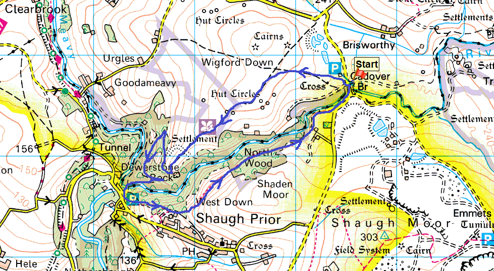
Start – Cadover Bridge
Route – Cadover Bridge – Wigford Down – Top of the Dewerstone – Shaugh Bridge – West Down – North Woods – Cadover Bridge
Distance – 3 3/4 miles Start time – 10.30am Time taken – 2 hrs Highest Point – Just above the Dewerstone 220m
Wet and murky from the parking spot by Cadover Bridge, still its Boxing Day and fresh air is needed!!From further up the hill with the Trowlesworthy Tors on the left behind the trees which holds the Counting House, which used to be the place were the china clay workers were paid in Victorian timesNormally you’d get good views across to Leather Tor and Peek Hill however its a bit grey today!Looking to Devil’s Rocks with the top of the Dewerstone down to the leftOn Devil’s Rocks now, the River Plym in in the valley on the rightHeading along the old narrow gauge railway track down to Shaugh Bridge, you pass many of these old quarry sites. Stone from here was taken to build Blackfriars Bridge in LondonThe railway track and path, one of the left behind blocks on the rightAt the top of the incline is this brake house, carts full of granite were lowered down the slope, in turn pulling up the empty carts (clever eh!!). This braking house ensured the full carts didn’t end up at the bottom in a mangled heap!Looking back up the inclineThe River Plym at Shaugh BridgeAnd again, this time from the wooden footbridge over the PlymOn Shaugh Bridge, the Plym and the Meavy (from the left) join togetherOn West Down, I’ve come from the left and I’m heading to the rightThe Dewerstone from a break in the trees before North WoodThis is a great National Trust path along hereNorth WoodThe path through these woods is called the clay pipe path, this pipe took the china clay from Cadover Bridge to the settlement tanks at Shaugh Bridge. The railway was also there to take the finished product to market along with the granite from the quarriesPlenty of water in the Plym near Cadover BridgeCadover Bridge at the end of the walk, now time for home and more festivities