l last walked in this area in September 2022, when I headed west from Port Quin to Polzeath, but it was the area to the east of Port Quin that I wanted to finish off. I had walked from Tintagel to Dannonchapel back in October 2021, remembering how difficult that section was. I’d looked at the map many times in the 3 years since, looking at the rises and falls, something that happens religiously along this part of the north Cornwall coast. I’d done 4 of them in that walk from Tintagel, seeing at least 3 more to do on the map. I’d also looked at splitting this walk into two but with the Lake District fells recently in our legs we figured we could manage it. The other issue was the return journey, the paths are a spiders web, criss- crossing the fields and the roads all seem to head to the coast, not useful if you need to head parallel to the sea back to your starting point. The only one that headed our way was the B3314, but this could be busy. The plan initially was to walk the coastal path to the turning to Dannonchapel, then about turn and head to the path inland for Hendra. This is where it went a bit wrong, we should have then turned right, heading to Port Gaverne, then take the paths towards Trewetha and then the Inscribed Stone marked on the maps. That’s what we should have done but we instead walked for a mile or two along the B3314, which was quite busy and not fun at all. All in all we racked up almost 14 miles on an 8 hour walk!! It was probably a good job we’d picked the bank holiday Sunday at the end of May for this walk!! We thankfully didn’t need to move much on the Monday! Another big section of the path done now though, and I have a short 2-3 mile walk from Polzeath to Rock to do and that will complete a long area of path from around Newquay to Hartland Quay.
Start – Port Quin
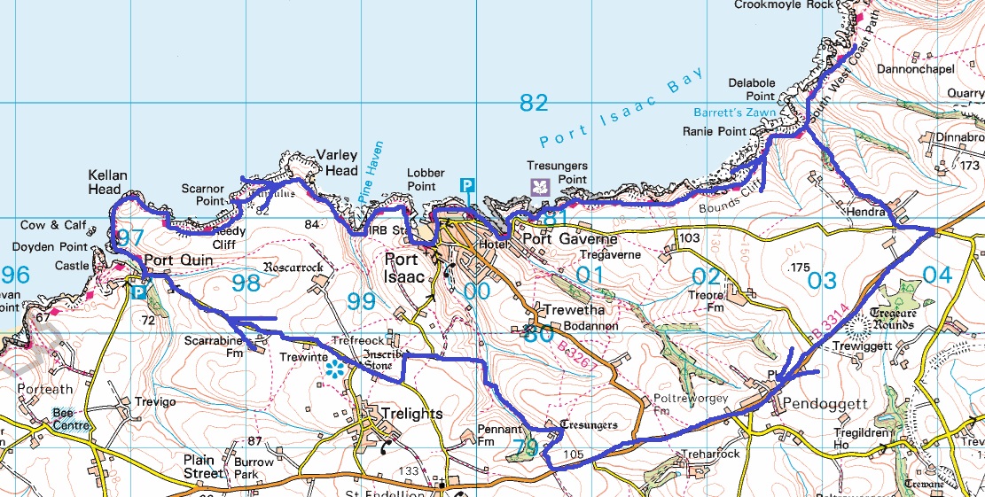
Route –South West Coastal Path – Kellan Head – Varley Head – Port Isaac – Port Gaverne – Bounds Cliff – Delabole Point – turn for Dannonchapel – Delabole Point – Hendra – Pendoggett – Tresungers – Inscribed Stone – Port Quin
Distance – 13.5 miles Start time – 10.50am Time taken – 8hrs Highest Point – Bounds Cliff 123 metres
Weather – Bit of cloud to start, then warmed up nicely with lots of sunshine and one heavy shower
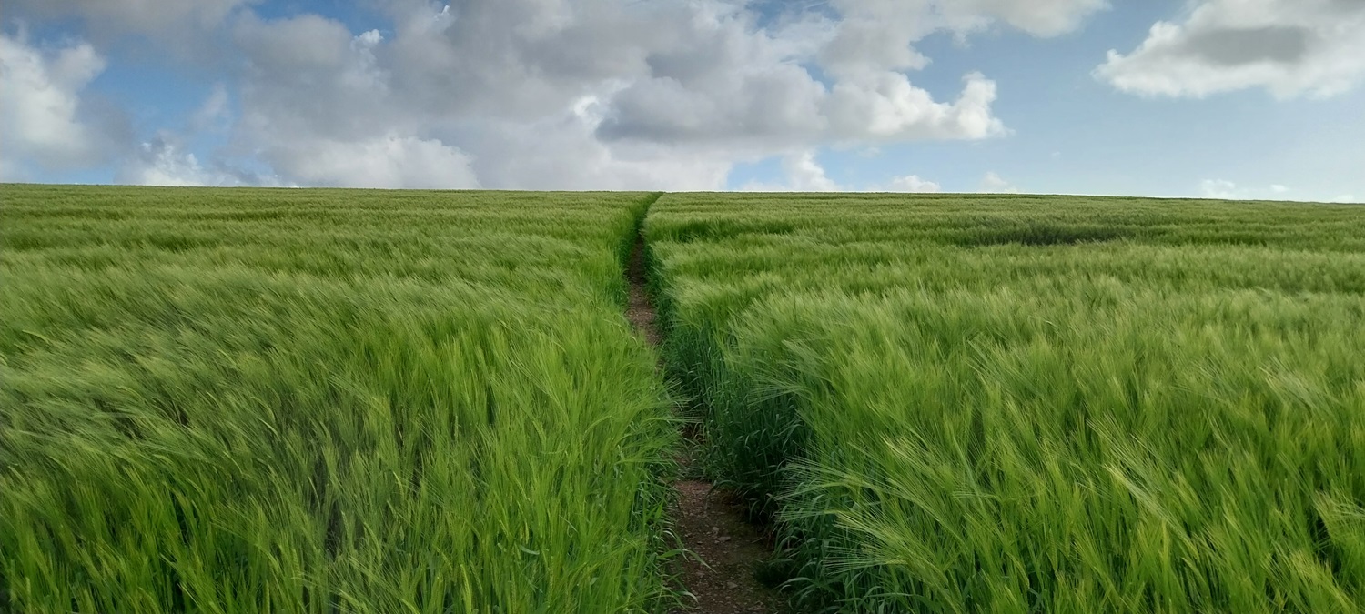
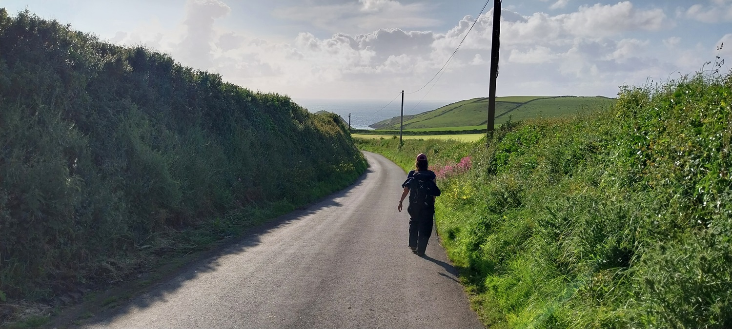
Port Quin, some dark clouds to start and we’d had rain driving here, but the forecast promised brightening weather and the sun being out here was the first sign they might be right.The mouth at Port Quin which heads into the Atlantic. The island is The Mouls which is off Rumps Point on the way to PolzeathOn Kellan Head looking at Varley HeadLots of Sea Pinks (Thrift) around todayFoxgloves at Varley HeadThe time difference between this photo and the one above is around 20 mins, but it looks like a different dayRounding Varley Head we got views towards Tintagel in the distance. The bridge over to the island can just be made outWe’d done our first down and back up again as we walk towards Lobber Point. Tintagel in the distance and the blue sky and sea making for a fine walk.Another sneaky up and down as I look back across the daisies to The Mouls and Rumps HeadHeading into Port Isaac now the bay of the same name stretching out beyondCornflowers and daisies matching the blue skies and white fluffy clouds aboveLobber Point on the left and a gorgeous bay belowPort Isaac, tiny, tiny streets, cafes, idiots with massive 4x4s trying to thread through mainly pedestrian streets, holiday lets and second homes everywherePort Isaac Bay beyond Linda. It was warming up nicely but we both had waterproof trousers on as the ground and long grass was still wetProbably sums up the issues they have in Port Isaac nicelyJust around the corner is the nicer and slightly quieter bay of Port Gaverne. I say quieter however the local hotel had some local “musician” belting out familiar tunes in such a way that it made recognising them impossible. Losing My Religion was one I picked upSpeckled WoodWe are near Tresungers Point here again Port Isaac Bay is lit nicely by sunshineStarting to head towards Bounds Cliff now and I was looking to count how many more drops and rises we had left, I think I counted 3 and maybe a half one. We would see. More concerning was the darkening skies, luckily the rain was out at sea at this pointSo looking back at the first down and up, the weather is coming from that direction so good to see some sunshine and blue skies behind us.A Painted Lady, these migrate from North Africa to our shores in April and May and are seen regularly through the summerThe climb to Bounds Cliff is nearly done and Port Isaac comes into view again as we gain heightBounds Cliff and looking forward, but there’s a drop down for us in a bit, out of sight at Ranie PointRanie Point is up on my left and below is Barrett’s Zawn and then up and around to Delabole Point. We also had a heavy shower drop a fair bit of water on us, making us throw on our waterproofs for 10 mins whilst it passed us.Delebole Point is ahead as we drop again, before climbing againCrookmoyle Rock is on the left there and that’s Jacket Point beyond that which is were we would sit and rest and then turn around back towards Delabole PointBack at Delabole Point and the huge landslip which has happened here. It will probably take the Danger sign (on the right) with it next time it goes.After climbing part way back up to Ranie Point we headed inland on a path to Hendra. This brilliantly placed fence had no stile so we went under!!Looking back to the coast as we reached HendraInland is the roof of Bodmin Moor, Brown Willy (stop laughing at the back!)On reaching Hendra my map on my gps didn’t have the same path layout as my gps due to it being an older version. May need to do some updating of my maps. So we went for the B3314, which wasn’t the best option with speeding carsAfter a mile or two we turned off for Tresungers, this is a 16th century grade 2 listed house, split into holiday cottages it would seemPort Isaac is that way. After Tresungers we crossed a field of skittish cows with their young before climbing up to this pointWe then crossed this lovely field of swaying wheatNo need to guess the wind directionOn the map is this Inscribed Stone believed to date from the 6th century. It sits on the road to Port Quin and the sign behind says Port Isaac on it under the Roscarrock wooden one fastened over itThe end of a lovely if brutally long day, we finally walk down into Port Quin at about 6.40pm. 8 hours all in all and almost 14 miles of some very difficult coastal walking. Thankfully it was a bank holiday weekend so no work in the morning for us, which was good as we hardly moved at all that day!
I can see why, old cottages and very little modern conveniences to spoil the shots. Its a tight little inlet but the car park is NT which helps me to park for free, so its a good starting spot
My kind of walk, though I’m seriously tired at the end of that! The thing is, you have to do them while you still can. It doesn’t get easier. Fabulous scenery. I’ve only ever seen Port Isaacs on TV. Shame what notoriety does.
It was a bit of a shame walking through Port Isaac, I expected it at Padstow/Polzeath etc but these smaller fishing villages can’t cope with the size of vehicles that people buy
I remember walking the section from Port Quin to Port Isaac – brutal was the word. I reckon even on that stretch and the return I clocked up the best part of 3000 feet of ascent. Fabulous stretch though
I nearly name checked you when writing this piece as you’d mentioned previously that the section out of Port Quin was hard, not sure what possessed me to then carry on to the next 3 up and downs to finish that part of the path completely. Just glad it was a bank holiday so had plenty of recovery afterwards


Looks like a long but fabulous walk. Joyous to come along with you.
LikeLiked by 1 person
Probably the longest day walk I’ve done on the coastal path, my feet were sore by the end
LikeLiked by 1 person
Port Quin used to be the go to place for filming period dramas.
LikeLiked by 1 person
I can see why, old cottages and very little modern conveniences to spoil the shots. Its a tight little inlet but the car park is NT which helps me to park for free, so its a good starting spot
LikeLiked by 1 person
I recall they used it for the 1970s series of Poldark, Frenchman’s Creek, The Eagle Has Landed, etc.
LikeLiked by 1 person
My kind of walk, though I’m seriously tired at the end of that! The thing is, you have to do them while you still can. It doesn’t get easier. Fabulous scenery. I’ve only ever seen Port Isaacs on TV. Shame what notoriety does.
LikeLiked by 1 person
It was a bit of a shame walking through Port Isaac, I expected it at Padstow/Polzeath etc but these smaller fishing villages can’t cope with the size of vehicles that people buy
LikeLiked by 1 person
Gorgeous walk.
LikeLiked by 1 person
I remember walking the section from Port Quin to Port Isaac – brutal was the word. I reckon even on that stretch and the return I clocked up the best part of 3000 feet of ascent. Fabulous stretch though
LikeLiked by 1 person
I nearly name checked you when writing this piece as you’d mentioned previously that the section out of Port Quin was hard, not sure what possessed me to then carry on to the next 3 up and downs to finish that part of the path completely. Just glad it was a bank holiday so had plenty of recovery afterwards
LikeLiked by 1 person